|
For our sixth wedding anniversary, Kelly and I decided to go camping like we did two years ago. Every year since we met, we have gone somewhere in late May to celebrate not only our wedding, but the first time we went out together (which are essentially the same date).
This year we decided to head down the South Coast and head inland from Ulladulla to Yadboro Flat. This is a site I have heard a lot about from magazines and web sites as well as a couple of friends.
After the adventures of our Christmas 2012/New Year 2013 trip to the Victorian High Country where we had problems with bash plates falling off and a total failure of a suspension bush leading to rough repairs in the most remote and hilly country imaginable, we are also keen to test out our repairs. Since then we have built a new bash plate (well my father-in-law did) and he also welded the bracket that holds the rear bash plate which covers the fuel tank.
In addition, we have a new suspension (Ultimate) as well as having had most of the rubber bushes in the rest of the steering and suspension replaced. In the almost five months since then the Prado has only done about 1200 kilometres as I have only used it for towing my boat and a couple of trips to and from work. In fact, the largest single part of the kilometres were done taking the car to the suspension company for the installation and check-up.
 |
Our route as recorded by our GPS using OziExplorer and uploaded to Google Earth
Home is at the top, Yadboro is top of the loop at bottom left |
You can download the Google Earth track of this trip by clicking here and looking at it in Google Earth.
In the three days before we leave for this trip, Sydney and surrounds has more rain than we have had in all of the previous couple of months put together. After almost four weeks without any rain, the rain starts on Wednesday, with Thursday and Friday having even heavier falls. A check on the Bureau of Metrology web site show that over 100 mm of rain has fallen at Brooman on the Thursday and Friday and almost that at Porters Creek Dam. These are to the south and north of Yadboro respectively.
We decide to go and if it is too wet, we will head inland a bit as there has been far less rain near Braidwood.
Day 1 - Saturday 25 May 2013 - Kareela to Yadboro Flat
As we do not have far to go, we have a very late start. We head off from home at 8:35 am. As normal we have the ShippShape roof-top tent on the car. We also have on board Veto, our dog (our daughter!). She has been so excited the past few days as we loaded the car, somehow she sensed that she was coming along with us.
We head south on the Princess Highway. It is sunny and 11.5ÂșC, a big difference to the past three days. At 10 am we stop in Berry to get some tissues (Kelly is recovering from a cold and in fact had to come home early from work yesterday) and a coffee for her. Once we get these we drive to the rest area which is just to the south (west) of the town's edge.
Veto has a run around while I have a cup of tea and Kelly has her coffee. This is a very nice rest area and one we have used many times. There are also tables and toilets. We leave at 10:40 am and continue south.
 | 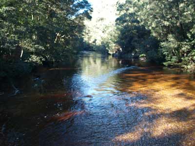 |
| Kelly and Veto in the rest area at Berry | The Clyde River at Yadboro |
At 11:40 am we stop at the Mick Ryan Reserve, a small park at the northern side of Milton where there are toilets. We are only here a few minutes during which I am perplexed to hear voices coming from up a huge fig tree. Turns out there are a few kids climbing up it. It is such a huge tree they can get way up inside it and are almost hidden from view. I bet they have a lot of fun here.
We take the first street to the right once we get into the main part of Milton. Any of the streets on the right will do. This street leads to Croobyar Road. We turn right and follow this out past the showground and then south as it heads towards the farming area. Here the road becomes Woodburn Road. Soon we are into an area where there is more bush than farmland.
We pass Wheelbarrow Road on our left. This comes from the Princes Highway just south of Burrill Lake. A few kilometres past here we turn right onto Clyde Ridge Road. You are now in heavily timbered country. At this intersection there are signs to Yadboro Flat as well as Pigeon House. There is also a tea room about 100 metres down the road.
Once you are past this point, look for suitable timber on the side of the road to collect for your fire. Do not wait till you are close to Yadboro Flat as there is virtually none around there to find. Another 7.8 kilometres on there is another intersection. This is where Yadboro Road starts. The Clyde Ridge Road actually turns left here and you continue straight ahead on the new road.
A further 4.3 kilometres along you will see the turnoff to the start of the walk to Pigeon House Mountain on the right and then another 6.8 kilometres sees the turnoff on the left to Blue Gum Flat Camping Area. Both these are in Morton National Park so we cannot visit them (since we have Veto with us).
We arrive at Yadboro at 12:40 pm. It is just under one hour's drive from Milton (38 kilometres). Yadboro Flat is in Yadboro State Forest and is located on the Clyde River. The whole road in is in very good condition and appears to be suitable for 2WD vehicles all the time. Even though over 100 mm of rain has fallen in this area over the past two days, there are no puddles of water at all on the road.
The Yadboro Flat Camping Area has three sections. The first is on the left as you approach the river. This is very small and really would only be used if the other two parts are full. There is a timber bridge over the river. The river is really flowing after all the rain.
On the left side after crossing the bridge there is a large flat section of the camping area which has a very nice grass base with plenty of trees for shade. There is a toilet as well as a number of fire-pit rings. Most of the barbecues are broken as it seems the vertical support has rusted away where it enters the ground. There is one car here, with a tent and a shelter. Looks like they are staying for a while. The southern most part of the spot looks like it floods a bit as there are channels dug in the ground to direct water away. Most of the spots are very good, some right next to the river.
We cross the road and look at the other side. This is a bit bigger and straddles a longer section of the river. There is another section that is a bit damp and there is a bit of water in some of the wheel-tracks. There are also quite a few spots down close to the river that are very nice. In summer they would be the prime spots. I should also point out that the very bottom spots on the rocky beach will flood as there is evidence that the water was covering this section in the past few days. Beware!
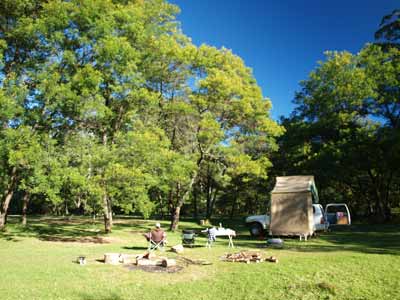 |  |
| Our campsite at Yadboro Flat | Another photo of the camp site |
As it is almost winter, we look for a spot that is free of trees and find one at the north-western end. The whole area has good grass cover except for the damp section. The northern side of the camping area is bounded by private property. This runs cattle and some horses.
Unfortunately, the cattle appear to be able to get through the fence (we see them do it) and roam around the camping area at will. This means that there is heaps of cow shit all over the place. Luckily it is not summer so it does not smell and there are no flies. A pity the farmer cannot/will not keep his cattle on his own property. By the way, he certainly knows they are out, we saw him come up later in the afternoon and he must have seen that at least 20 were outside the fence.
Anyway, we stop in the cleared area and get out our table and chairs. We have lunch and relax in the sun. It is still quite cool, perhaps 17ÂșC, but with the sun it is gorgeous. After lunch we leave the chairs and table where they are and head off up the road to the north. For the past 15 kilometres as we approached Yadboro, we were looking for timber to collect for our fire. There was nothing at all (hence my previous warning to collect it early on as you come in). There are some large pieces of timber at one of the other camping spots so Kelly and I carry them over to our spot.
A few kilometres up the road we see a track off to the left. We head up there but it only goes a few hundred metres. I find a small branch that I cut up up, but this is not enough to last us. Back on the main road, we spot a good sized fallen tree. I cut this into pieces and we had back to the camping area.
We spend the rest of the afternoon reading in the sun (and moving our chairs to stay in the sun), with the occasional break to chop some of the large sections of timber into more manageable sizes using our small axe. I have brought some dry timber (pine) from home as I thought we might need some dry stuff to get the fire going.
While reading we notice that all of a sudden there are dozens of tiny birds on the ground around us. They are superb blue wrens. Some are females, but most appear to be juvenile males (they have a blue tail but not the blue chest of adult males). We see no males at all. Unlike other places we have seen them (including sometimes in our backyard), these ones are totally unafraid of us. They hop around our feet, jump up on the table and even scramble all over the car chasing insects. They are the cutest little things.
Meanwhile, Veto decides she has to bark at the cows. She does not like them and has done this before when we were camping on the Murray River in late 2010. She also decides to roll in cow shit. She has chunks of it on her head, so Kelly had to take her to the creek to wash it off. Bad girl!
At 3:30 pm the sun has gone behind the trees and a fog starts forming on the paddocks next door. It is very eerie looking. It is now 14ÂșC and quite cool so I start the fire. It takes a while to get going as the timber is so wet (a hint, use the timber as a border to the fire so it dries out).
About this time another car comes in and sets up camp down near the river. There are now three cars here, but we have a good distance between us.
Before it gets dark, I get all the things out and ready for dinner. Makes it a lot easier than doing it all in the dark. By 5 pm I have a good fire going. I break out the cheese and biscuits and beer and wine and we sit in front of the fire with Veto on my lap.
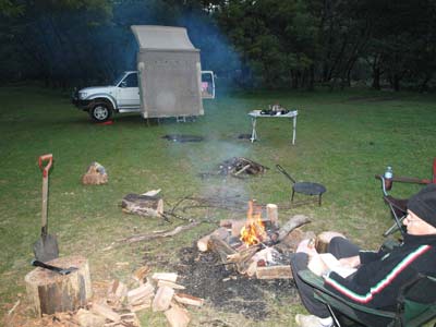 |  |
Michael at the campfire, it is not
even 4pm and it is cool | Kelly around the campfire, note the fog in the paddock |
After 6 pm I put on a garlic bread I have left over from a few days ago. This is easily heated by putting on the fire and moving it regularly. I set up the Bidji BBQ. Normally I use small twigs to heat this but they are all soaking wet. I end up using some of the coals from the fire and small pieces of the pine I brought from home. Soon it is getting warm so I put on the onions, Kelly's mushrooms and some sausages.
Now we are cooking, they are soon almost done so I put the two T-bone steaks on. With good heat under the BBQ, they are also cooked to perfection pretty quickly. Kelly meanwhile has cooked a packet pasta. By now, Veto is exhausted from chasing the cows and exploring everywhere, so Kelly puts her to bed on the front seat of the car. She seems happy to be in there.
The steak is beautiful, tender and cooked to perfection (even if I do say so myself). I heat up some water and we do the washing up. We then sit around the fire and read some more. During the afternoon I was reading the Sydney Morning Herald and I am now onto the last parts of it. We use headlamps to read, better than a bright lamp between us.
The moon comes up, it is full tonight. Once it clears the trees it is almost like daylight, except the fog is making it seem like a scary movie set. By 8 pm it is down to 6ÂșC and by the time we go to bed at 10:30 pm it is only 3ÂșC.
Weather: Sunny, max 17ÂșC Arrived: Yadboro FlatTime: 12:40 pm Distance: 241 kilometres
Day 2 - Sunday 26 May 2013 - Yadboro Flat to Yadboro Flat
Weather: Fine, 1ÂșC minimum
Happy Anniversary! Today is our sixth wedding anniversary, the time has passed so quickly since that day at Bare Island where we were married. Best decision of both our lives we still say. Anyway, it was a very cool overnight but we were not cold at all. As we have no real plans for today, there is no rush to get up. I try to listen to the ABC Radio News but I cannot find a station, so I have to put up with a commercial station that comes in and out.
We get up at 8:30 am and it is still quite foggy. The sun soon comes over the trees and we sit in the sun having breakfast and then reading. I have started a book called Dune is a four-letter word by Griselda Sprigg. This is about Mrs Spriggs life, but concentrates on her adventures with her husband Reg and children Marg and Doug. These really were an adventurous quartet. They were the first people to drive across the Simpson Desert (1962). They did it from west to east and then in 1964 from south to north and then in 1967 all over the place. What adventures they had. An excellent book, Google it and buy it, thoroughly recommended.
Veto did not bark at the cows this morning, but even worse she again decided to roll in cow shit. This time she has got it all over her back and really stinks. We take her down to the water's edge next to the bridge. Kelly washes her totally in the very cold river water. She does not like this at all (that is the point of using cold water). We dry her as best we can using a towel we brought along for just this purpose. At least she now does not smell.
 |  |
| Kelly drying Veto after her bath | One of the many Superb Blue Wrens,
this one is on the Prado's bonnet |
We sit in the sun reading till 11:00 am when we decided to pack up. We are going to go for a drive and see if there are any other camping spots further south. We leave at 11:25 am and it is a nice 19ÂșC. We head north out of the camping area along Yadboro Road. Just over 3.5 kilometres up the track on the right is the turn off to Long Point Camping Area and the access to The Castle. This is in Morton National Park so we cannot enter.
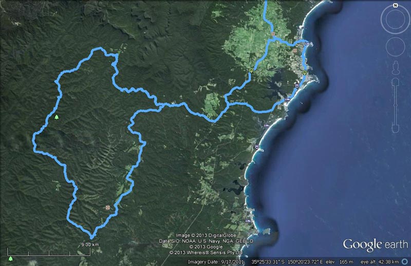 |
Our route on Day 2 as recorded by our GPS using OziExplorer and uploaded to Google Earth
Yadboro is top right of the loop at left, Shallow Crossing is bottom left |
Past here the name of the track changes to the Western Distributor. Again, it is a very good road, suitable for cars. Along this section of track there are views of the spectacular sheer cliffs and The Castle, but no real spot where you can get a good photograph. We stop at one point and manage to take a couple of photos and also at another spot where I cut some excellent timber for tonight's fire (we need a lot for a camp oven roast).
There are a number of good tracks that head off to the left along here, including Blue Gum Flat Road and Mares Hill Road. The first leads to the camping area at Blue Gum Flat and then Yadboro Road, the second goes to Clyde Ridge Road. We end up turning off at Cattlemans Fire Trail. This goes to the left and follows a ridge back to the east.
 |  |
| Pigeon House Mountain from Western Distributor | The Castle from Western Distributor |
There are a couple of other tracks that come off this one, but the fire trail is pretty obvious. After 6.1 kilometres the track drops down to the Bimberamala River and we cross this. It is not very wide or deep normally. We climb back up the ridge to about 220 metres (maximum height has been only just over 300 metres along this whole route) and a bit further on to about 270 metres. We also see a number of lyrebirds along this whole section of road.
Only 3.1 kilometres after crossing the river we come to an intersection where Cattlemans Fire Trail appears to go straight ahead up a steepish hill while the main (and what appears to be a newer) trail goes to the left. We take the left one as we are only a few hundred metres from the main road, Clyde Ridge Road. At the intersection we see another track coming down from the same hill on our right.
I also notice a sign at the intersection, almost overgrown. It says Mogood Lookout and points up the hill. We turn around and take the 4WD only track a hundred or so metres up the hill and find an amazing sight. The lookout is about 390 metres above sea level and has a small loop track around a trig station. The remarkable thing is that it has 360Âș views, with the ocean visible to the east and the plateau towards Braidwood to the west. North you can see Pigeon House Mountain and The Castle.
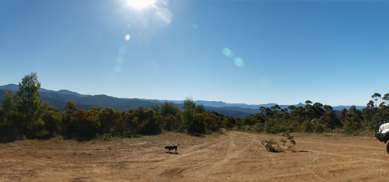 |
| A panoramic photograph from Mogood Lookout looking towards The Castle and Pigeon House |
It appears that this is used as a helicopter landing spot as all the trees are only a metre or two high, apart from one large one. For some reason, perhaps to help the spot stand out from the air, there is one tree on the western side that is about 15 metres high. Anyway, this is a great spot and well worth visiting. It is now 1:00 pm so we decide to have lunch while we admire the views.
While we are here, we hear lyrebirds singing from the bush to the north-east of us. Seems like the one we saw just before coming up the hill is sounding off. It is really a beautiful song. Also while we are here, a few vehicles come up but they do not stay long.
We leave at 1:35 pm and head back down to Clyde Ridge Road and turn right (left would take us back towards Yadboro Road - we will pass this intersection in an hour or so). About 4.5 kilometres along we come to Drurys Road and we turn left here. At the bottom of this we turn left again into The River Road. Only 4.3 kilometres along is the Clyde River and what is called Shallow Crossing. This is a causeway across the river. This is 27 kilometres from Yadboro and the time is 1:45 pm.
Just before the river is the Shallow Crossing Campground. This is a privately run camping area that runs along the river for a few hundred metres. We go in and have a look around. There are plenty of small shelters with tables under them. There are quite a few groups of people here, most seem to be motorbike groups. Some appear to be in the process of leaving, but others do not. As we are not keen on camping near large groups, we decide that we are not going to stay here.
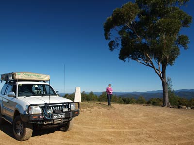 |  |
| Kelly on the top of Mogood Lookout | Shallow Crossing |
I understand that the cost is $8 per adult a night ($4 for children?) which includes hot showers. There are also toilets here. I expect that this place is very busy in summer and over holiday periods. We leave and cross the river via the causeway. On the other side there is a track leading off to the left. This leads to a picnic area. It is part of the travelling stock route, but you cannot camp here. I am not sure why you cannot camp in TSRs, this seems strange but we have encountered this before.
We follow The River Road to the north. It changes into Brooman Road and then at the intersection with Carrisbrook Road we turn left. This road (and some others earlier) head out to the Princes Highway if you turn right at them. Exactly 20 kilometres from Shallow Crossing is the intersection with the Clyde Ridge Road. This is on the Clyde River. We turn left, thinking there may be a camping spot here. We only find a very poor spot where one vehicle could set up. We turn around and follow this back to the north-east.
At Yadboro Road we turn left and at 2:50 pm we arrive back at Yadboro Flat (this section takes 30 minutes). We set up camp in the same spot we had before and I soon get the fire going. Tonight we are having a baked dinner so we need lots of coals for the camp oven. The fire is going much better than yesterday as the timber is better and also I think a lot drier. I also remember that I have not checked the chicken we are cooking. It was frozen when I put it into the fridge a few days ago. I get it out and realise it is still a bit frozen. I put it on the bonnet to use the warmth of the engine to finish the defrosting.
I set up the car shower and we both have a hot shower to clean off the dirt and smoke from the past 36 hours. Between tending to the fire and the shower, I read more of my book.
Before it gets dark, I also peel the vegetables (potato, carrot, pumpkin and sweet potato). I also prepare dessert, my apple crumble pudding. For this I need to make the batter (flour, sugar, salt, water and butter) and then put it all together with canned apples (easier) and sultanas. A check of the chicken shows that it is now defrosted.
We have our normal pre-dinner drinks and nibblies at 5 pm. Tonight we have some excellent Australian sparkling wine (I have a few beers to start). The first is a 2009 James Hardy special bin I found the other day. Very nice. At 5:15 pm I preheat the camp oven (by placing on the fire) and dig a small hole to put it in. At 5:30 pm we put the chicken on and 20 minutes later the vegetables go in.
Veto is not as tired today as the cows have all disappeared and she did not spend the whole afternoon running around. She sits on my lap as I read my book. The dinner is ready about 7 pm, but some of the vegetables needed more (carrots especially). I think we need to put them all on at the same time, this is not the first time we have had slightly undercooked carrots.
The chicken is very tender and the vegetables are mostly really good. We have a 2009 bottle of Australian Chandon vintage sparkling wine to go with the dinner, it is excellent. After dinner and a feed of chicken bits, Veto gladly goes to bed in the car.
As soon as the main meal came out of the camp oven, I put the dessert on. It will take about one hour to cook. We finish the Chandon and open another bottle of very good Aussie sparkling.
 | 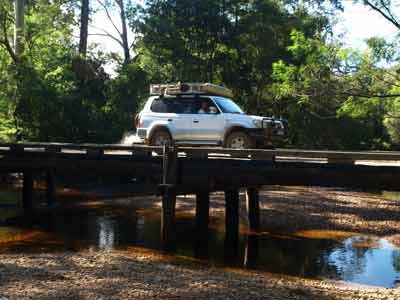 |
| The remains of the town of Brooman | Crossing the bridge over the Clyde River |
We sit around reading until the dessert is done. We end up eating the apple pudding with double thick cream at about 8:20 pm. Very nice way to finish off our dinner.
At about 9 pm Kelly hears something. She gets up and walks over to the fence that separates the farming paddock from the camping area. Kelly makes a noise and out of the fog comes a unicorn! Well, that is what she thought it was, not sure if it was a combination of the alcohol and the fog or just the alcohol, but she swears that is what it looked like. It is one of the horses we saw in the paddock yesterday.
Kelly goes down to the gate and the horse comes right up to her. She scratches it and it seems to like this. Another white and a brown horse also come up to her. She spends ages with them.
When Kelly finally comes back to the fire, she insists we have a dance and pretend it is to our wedding dance song, Unchained Melody by The Righteous Brothers. I sort of try to sing it and we dance around the fire for a minute or two. How romantic!
We end up going to bed about 10:30 pm.
Weather: Fine, max of 19ÂșC Arrived: Yadboro FlatTime: 2:50 pm Distance: 77 kilometres
Day 3 - Monday 27 May 2013 - Yadboro Flat to Sydney (Home)
Weather: minimum of 5ÂșC and fine
It was a lot warmer last night and we needed to pull the blanket off to stop overheating. We get up at 9:30 am and have breakfast. By now it is a lot warmer, about 14ÂșC.
We read again while sitting in the sun. At 11:30 am we make a decision to start packing up. The Shippshape is now mostly dry but there is some dampness on the southern side. I turn the car around so that the other side will dry. It is a lot easier to do this now rather than when we get home. Although it has not rained, the thick fog and heavy dew has completely wet the tent.
We pull all the bedding out of the Shippshape before we close it up and pack everything away. We end up leaving at 12:15 pm. We head back the way we came in on Saturday. It is 25 kilometres to Wheelbarrow Road. This goes off to the right towards the Princes Highway. As I mentioned earlier, it comes out south of Burrill Lake. We drive north on the highway and go through Ulladulla and then take the turnoff to Mollymook.
It is 41 kilometres from Yadboro Flat to here. We pull up in the car park next to the beach where there are undercover tables and barbecues. We make up some lunch while Veto has a run around on her leash.
It is a very nice spot, with the beautiful beach right in front of us. We stay about half an hour and head off about 1:45 pm. It is 202 kilometres to home and we get there at 4:40 pm after a good run (and a stop).
Weather: Fine, maximum of 16ÂșC Arrived: KareelaTime: 4:40 pm Distance: 243 kilometres
Summary:
This was another very nice weekend, with good weather, good company (Kelly and Veto) and great food and drink. As well, we got to see some spectacular places we have never seen before. We did 553 kilometres on the weekend, most of which was on the highway. The sole real cost of the weekend was the fuel which was about $xx.
| 
 v6.00.307 © 2003-2005