|
Over the period since 2000, one of the most popular dive trips that St George Scuba Club has run has been its "Four Wheel Dive Weekend". For this trip we have departed Sydney about 7 am and headed north to Swansea. Here we have dived under the twin bridges that carry the Old Pacific Highway across the entrance to Lake Macquarie. Check out the Swansea Bridge and Swansea Channel Driftdive site pages for more information.
After the dive, which is dependent on the tide, we are normally finished by about 11:30 am. We then head north to Charlestown and cut across via the Newcastle University to Mayfield and then Kooragang Island and over the Stockton Bridge.
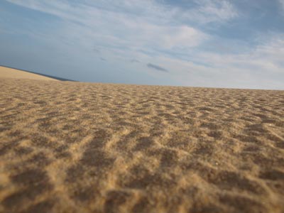
Stockton Beach is located immediately north of Newcastle. This beach extends for about 30 kilometres from the northern side of the Hunter River to just south of Port Stephens. The beach is huge, at some spots well over a kilometre wide. The sand dues are enormous in spots and create an almost desert like scene. It is a unique location in New South Wales, the only beach that has huge expanses of sand dunes that you can drive on. As such, it is a very popular site for four wheel drives. It is also extremely popular with beach fishers.
From the centre of Sydney it is just over two hours to the access point. At the end of the F3 Freeway, follow the Pacific Highway route towards Taree. This takes you right at the roundabout and then onto the New England Highway. At Hexham, turn left and go over the bridge. Get in the right lane and take the first on the right (sign-posted Nelson Bay and Williamtown). Follow this road till you come to the Stockton to Nelson Bay road. There is a large roundabout here, go straight ahead into Lavis Lane and then turn into the service station on the corner. You need to stop here as you have to purchase a 3 day use pass ($10 in 2007).
Once you get your pass, come out of the service station and turn left into Lavis Lane. Follow this till you see the sand dunes right in front and a track off to your right. Go up the track and after a few hundred metres you will see a largish flat area with a track heading off to the left. Stop here and let down your tyres. I would suggest dropping your air pressure to at least 16 psi for large heavy 4WDs and maybe 20 psi for light ones. You may need to drop further.
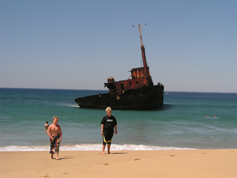 |  |
| The remains of the wreck of the Sygna | Ray coming down a dune |
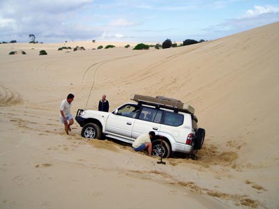
Once you have the right air pressure in your tyres, head up the track. After about 200 metres the track becomes a sand track, only wide enough for one vehicle in most spots. Take car as you go, there may be a vehicle coming towards you. This first section is generally the hardest to do as the sand is very soft. At first you go through the trees but then it opens up into a wider track between some dunes. This is very soft and you need to really put your foot down to get through. Past here it opens up again into a very wide desert like spot. Ahead is the first large dune that needs to be conquered. On all my trips here, this is the one that has always been the hardest for me to get up as the sand on the western side is very soft.
Once at this spot, wait for the rest of your group to catch up and then plan your day. Before going any further, some hints to help you have a safe day:
 |  |
The lone tank trap located right at the southern end of the beach
Photo by my nephew Scott Barry | The wind can make very interesting patterns on the sand
Photo by my nephew Scott Barry |
Normally we head to the beach and then south to the wreck of the Sygna at GPS S32° 51' 34.3" E151° 50' 33.5" (note all GPS marks on this page are using AUS66, not WGS84). This is the largest ship to ever be wrecked in NSW. It was washed ashore in the huge storm that hit Sydney and the central part of the NSW coastline in May 1974. The bow of the ship was later salvaged but the stern section remains just in the breakers. It is really falling to pieces now.
 |  |
| Some of the tank traps that protude between dunes | Les coming down a dune |
If the tide is low you can drive down the beach. Keep well above the waterline, do not drive like they do in 4WD advertisements. The last thing you ever want to do is to drive in salt water, even if there is only an inch or two, it will spray up all over your car and you will end up rusting it out. If the tide is high or the seas very large, there are a couple of tracks that run parallel to the beach just behind the first sand dune. This is actually the easiest place to drive, but not as much fun.
Anyway, as I mentioned, we head to the wreck and by the time we normally get here, it is time to stop for lunch. In summer, if the seas are calm, we might have a swim. However, be very careful as the seas here are quite dangerous and there are many rips.
After lunch we normally head south and inland. There are some nice dunes to test out as well as a couple of sand mining spots to explore. Some of the old sand mining locations are now being encroached by sand and it can be very soft. A couple of times we have gone down into one and not been able to get back up. At one of these spots I have had about 50% success in getting out. Some days the sand is harder (after rain) and I can get up but other times no matter what I try I cannot get out. Luckily you can run along the old access track and about a kilometre south you can get out as the sand is harder and the dune lower.
Right at the southern end of the beach (at least the furtherest south you are permitted to drive) there is a bit of a fence. This is where I think you are supposed to stop, but it is not clear. Anyway, just behind the beach and about 40 metres south of the fence is a lone tank trap. This is the sole remaining one at this end of the beach as far as I know. The location is GPS S32° 51' 34.3" E151° 50' 33.5".
The tank traps were put here during World War II as a barrier in case the Japanese ever decided to launch an invasion via the huge expanse of Stockton Beach. I do not know much of the history as I have never been able to find any definitive information about them. The tank traps consist of a series of pyramid shaped concrete blocks which appear to have originally had a steel pole sticking out of the top. I presume that these poles held barbed wire. There are more up north, see later in the article.
From here we normally head north along the edge of the trees. The dunes here are very high and there is normally no trouble. Beware that a lot of these dunes can have very steep drop offs on the northern side. They are not all that high, but you can damage you vehicle if you dig in when landing (I ripped off the sump guard one day).
 |  |
Our favourite camp site
Note the kids on the top of the
dune about to slide down and one half way down | The campfire at the end of an evening |
Back past the entry spot it really opens up and this is where the greatest width of sand dunes are located. Do some exploring, but make sure you either have radio contact with your other vehicles or you keep them in site. It is no fun to get bogged and have no-one around to help.
As we always camp overnight when we go to Stockton, we generally start looking for a camp site about 4 pm. Depending on the wind, we pick a spot that is protected. There is a very good spot at GPS S32° 49' 26.8" E151° 54' 48.9". This is flat, with protection from southerly winds. It has a very large dune to the south thatn provides the protection and it also is great for sliding down (bring a boogie board). The dunes change shape a lot and this one in 2007 was not as high and had a second level compared to other years.
You can also camp at GPS S32° 48' 52.8" E151° 55' 50.3" but you need to check this spot out before all going down as it can be quite soft and there is only one way out, that is back up the way you got in. In 2007 I doubt that you could get here.
 |
| Our favourite camp site from the top of the dune in the photo above |
You will need to take your own timber if you want a fire for cooking or other purposes, as there is very little around. We find if each car brings some old fence palings or a cut up pallet, you will have enough.
Once camp has been established (make sure you bring sand pegs for your tent), we generally go for a walk or slide down the dunes.
It can be quite eerie camping out here. After dark, walk a little way from your camp and look back, it looks like you could be out in the middle of the desert.
The next day we normally have a late start. Once we get going, we go and look at the tank traps. They are roughly at GPS S32° 48' 57.3" E151° 55' 48.4". The traps here are placed very close to each other (see the attached photograph).
 |  |
Some of the back dunes at Stockton Beach
Photo by my nephew Scott Barry | Tyre tracks can make very interesting subjects for photos
Photo by my nephew Scott Barry |
The tanks traps appear to be in a line (although a bit of a curved line) and as the sand is constantly moving, their exact location changes. Some get uncovered while others get buried. Be careful driving in this area as you do not want to hit one that is buried just under the sand. You can actually anticipate where the next one will be by measuring the distance between (7 and a bit of my feet) and the curve. Dig down and you will find the next one. In 2007 only tiny sections were visible whereas two years earlier almost full ones could be seen. In 2009, even less was visible.
From here we head towards the water and along the flatter areas. If you run parallel to the beach you will come to "Tin City". This is like some post-Apocalypse Mad Max town, created out of corrugated iron. In fact, it is a small fishing village, built many years ago. I am not sure if it dates from the Great Depression like some other localities in NSW (the Myall Lakes ones that no longer exist were not from that era, just squatters).
It is an interesting place to stop and look at how people have created a place out of scrap and used some ingenuity to make their time spent there better.
 |  |
| Tin City | Heinz and I digging me out
of a very soft patch at the bottom of a dune |
After this we head north along the inland road and eventually come back onto the normal roads at the Anna Bay exit. Note that there are only two places you can get on or off the beach, the Lavis Lane road and here at Anna Bay.
You will need to pump your tyres back up before heading off. If you do not have a compressor, then drive slowing to the north to the Anna Bay shopping centre and fill your tyres at the local service station.
From here, you can go to Nelson Bay or explore the beach areas near Anna Bay or Boat Harbour before returning to Sydney.
A great weekend out, with hints of very remote Australia only a couple of hours from the centre of Sydney.
|  v6.00.307 © 2003-2005

