|
A short distance west of the Princes Highway south of Nowra there are numerous national parks and state forests. Some of these have some fantastic scenery and you can spend a lot of time exploring the areas. Some of the tracks are very easy but others are extremely difficult. Over the weekend of 21 to 22 July 2007 Kelly and I ventured to the area with our four wheel drive Club, the Jeep Club of NSW.
ROUTE DOWNLOADS
You can download the Google Earth track of this trip by clicking here and looking at it in Google Earth.
Saturday 21 July 2007
The plan is to meet at the McDonalds at South Nowra at 8:30 am. It is about 160 kilometres from our home so we leave at 6:30 am and head down the Princes Highway and F6. It is a cold morning and after the extremely bitter weather of the previous week (Sydney's coldest morning for over 20 years) we are glad we are in the heated car. We arrive at Nowra a little early as their was very little traffic on the road once we pass Wollongong. We drop into the shopping centre at Nowra to pick up a couple of things we had forgotten, some we can get as Woolworths and all the food places are open but one item we cannot get as the majority of shops are still closed.
We arrive at Maccas to find that we appear to be the first here. Amazing, this is a first, we are normally the last to arrive. We order breakfast and I go back out to the car and while there, I hear some of the others on the radio. I find out that we are not the first to arrive as someone I thought I had met before was already inside when we arrived. Gary and his son are not members of our Club but Gary came to a AGM a few years earlier (hard to forget him as he has a ZZ Top beard). Kelly and I introduce ourselves and chat while we wait for the others to arrive. Gary is driving a Jeep Cherokee.
About 9 am the others turn up. There is Ray in his Toyota Landcruiser 80 series with John as his passenger, Warren in his (well his wife's) Cherokee and Brett in his Nissan Patrol with passenger Ken. All are members of the Club.
After breakfast, we head off south with Ray leading. About 26 kilometres south of Maccas at Wandandian, we meet up with Alex, a friend of Gary's who also came to the meeting a few years back and also has a ZZ Top beard. He is also in a LandCruiser 80 series. We head west along Wandean Fire Trail and soon leave the tar and enter the state forest. Our first stop is the lookout at Jerrawangala. This gives excellent views to the coast. It is just over 400 metres high here and you can see Jervis Bay, St Georges Basin as well as Ulladulla.
 |
| The view from Jerrawangala Lookout |
While we are very close to the Serpentine Road, we decide to do a bit more four wheel driving before getting back on the main road. We backtrack a little and then head north-east up Slab Hill Fire Trail. This turns north and then north-west where it becomes Cassia Fire Trail. We get to the Braidwood-Nowra Road (Turpentine Road) and find that it has been tarred since we had been here last. This road is in the process of a long overhaul and is being upgraded for its whole length from a narrow dirt road to tar. We did not know that the actual work had even started. We turn onto the road and head west. Along the way Ray stops and checks out where we plan to exit tomorrow afternoon to make sure that the track is not locked off. It is okay.
We stop at the Tianjara Falls parking area. This is where Tianjara Creek drops off the plateau into the valley below. There is a lookout here, with a small section that protudes over the cliff and lets you look straight down to the forest below.
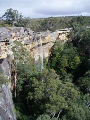 | 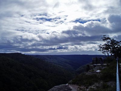 |
| Tianjara Falls | Tianjara Lookout |
We continue along Serpentine Road about 800 metres after crossing the creek we turn right onto Yarramunmun Fire Trail. This runs north to Yalwal, about 26 kilometres away. This is a very easy track, as it runs on the top of the plateau. After 13.7 kilometres this trail continues ahead and off to the left the Yarramunmun Tops Fire Trail goes off. We take this and about 6.2 kilometres along we stop for lunch at the intersection with the track that we are planning to take (not sure of its name as it is not on my computerised map). Yahwal and Danjera Dam are straight ahead. It is still bitterly cold and some of us are rugged up with beanies and heavy jackets.
After lunch we continue on our way. About 250 metres down the track it starts to drop off the plateau. This section of the track gets steep in parts but was not overly hard. After dropping off the plateau, the track turns north and runs this way for some kilometres. In spots the track has small diversions where it goes around fallen trees etc. It is 2.7 kilometres down to the Yarramunmun Fire Trail where we turn left. It has taken almost 30 minutes to travel this distance. We follow this fire trail to the north. There is some water to cross, as the rain over the past few weeks have gathered in the low spots of the track. We pass a track that heads off to the right down to the bottom of the valley.
We end up at a spot where the track turns and runs down a steep ridge. This is 1.1 kilometres and it takes 22 minutes. This next section of the track is in a very bad condition, with many wash-outs and huge holes. If you had a very old vehicle that you did not care about, then you might try it. Apparently it is called Suicide Hill by the trail bikers. We all decide that we are not going down this one.
We backtrack to the previous track and go down this. This is near a spot marked on the Yalwal 1:25,000 map as Underwood Point. This also runs down a ridge and a short distance along we stop. The track here is also not the best. The last time the Club was here one of the members rolled his HiLux. We look at the spot and try to see how it may have happened. Luckily there is a parallel track that while steep, is not as rutted and washed out. First gear low sees us down safely.
 |  |
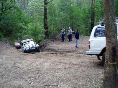
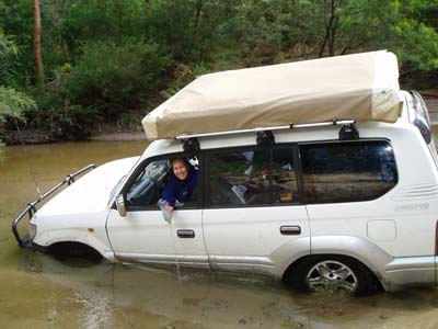
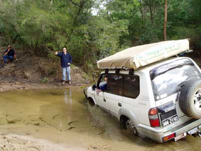
| The end of Yarramunmun Fire Trail | Me stuck at the exit from Yarramunmun Creek |
The track runs flatter from here and we soon arrive at the Yarramunmun Creek. It is 1.8 kilometres from the intersection to this spot. This is at the intersection with Boolijong Creek. Here we have to cross over the creek formed by the two creeks and climb a very steep bit to get up off the creek floor. There are two tracks up and we decide to give the right one a go. Ray goes first and makes it, with a bit of power and the assistance of his diff lockers. I go next but cannot get up over a huge step. While I can get my front wheels up, I then lose traction at the rear. After many attempts I give up and for the first time, need to be snatched out. Ray does this fairly easily.
Of the others, only Gary makes it up unassisted. He also has a diff locker. In the end, Brett and Alex come up the left track. The next section from here has about three or four different ways to go. One has a huge number of large steps, another a lot of small steps and the others less steps. I go first and with Kelly directing me, we make our way up, zig-zagging as we go. At the top there is a large area that would be suitable for camping. In fact, there is a better area a hundred metres or so to the right that we see tomorrow.
 |  |
| Me getting snatched up from Yarramunmun Creek | Ray going up the hill from Yarramunmun Creek |
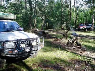
We continue to the north along an unnamed track. The going is slow, with lots of large muddy (and smelly) water pools. There are also a few diversions. It is 2.7 kilometres and it takes us 22 minutes. Just after 4:15 pm we arrive at the camp site. Its location is S34 57 42.6 E150 25 06.2 using AUS66 as a datum. This is located next to Yarramunmun Creek and has enough space for about 10 cars, although 8 would be a more comfortable number.
Kelly and I are the first ones set up (about three minutes), although Ray and his new awning is close behind. Kelly and I have decided to put up an awning at the rear to provide shelter from the rain over the rear door and to eat under. We have never done this before so it takes us a while to work out where we need to tie off the tarp on the car.
We soon have it worked out. In the meantime, some have collected firewood and then shortly after we have the fire going. We get our chairs out and have the first beer together with some biscuits and dip.
It does not look like it is going to be a really cold night as the wind has dropped and there is a fair bit of cloud around. Kelly and I have some garlic bread and then a great meal of Scotch fillet and sausages, washed down with beer and wine. After dinner we all sit around chatting and Kelly gets out the schnapps. This soon disappears as most have a drink or two.
We go to bed a bit after 10 pm, exhausted by the beers and early start. During the night it is very warm, we even have to take off some of the coverings on our bed. It rains for a while about 4 am but this is not heavy.
Sunday 22 July 2007
I get up at 7:30 am and by 8 am everyone is up bar one (guess who). We have a leisurely breakfast and finally leave a bit after 10 am. We decide to look further along the track to see if we can get though but after a couple of kilometres we come to a section that came up from a creek that is too washed out to try. We head back to the south and go back to the junction of the two creeks were we crossed yesterday afternoon. On the way we pass the camping area that we went through yesterday and see the even better one I mentioned earlier.
 |  |
| The campsite next to Yarramunmun Creek | Me coming through a very muddy bog |
Ray's plan is to take a track that he did a while back. This starts between the two creeks. He goes down the track that we came up yesterday and then crosses the smaller creek and just gets up onto the start of the track. Here he strikes the first of many problems that will occur this afternoon. In front of him is a huge step. The track has been washed away below a large tree root and it is impossible to get over. After about 20 minutes of work, he creates a ramp that lets his left wheel get over the step while his right straddles the edge of the track.
I go next. At the bottom of the down track I take aim at the new track. A problem is that there is a tree stump under the water and I have to go a bit to the right to miss it. Well, I go a bit too far and my right wheel hits an object under the sandy bottom. I cannot go forward. I try to reverse but I have now sunk into the very soft sand on the bottom of the creek. Sh!t. I cannot go back or forward. The water, luckily, is only up to the bottom of the doors.
Warren comes down and a snatch strap is attached to the rear of the Prado. Well, we get into a worse situation as we only move a few centimetres and the front left drops so much into the sand that the water is now almost up to the top of the wheel. Water is pouring in the front passenger door and Kelly has to start bailing with a quickly constructed bailer made from a water bottle. More attempts at snatching achieve nothing, we move less than a metre. As there is no way to pull me straight, the soft sand on the creek sides does not permit any angled pull to give any real thrust.
Luckily Gary has a winch and he comes down and using a pulley, it is attached to my vehicle. The first go gets me out. Kelly and I cross the river and deflood the vehicle. The whole left side of the floor is wet. Luckily there is nothing of value here and we had quickly lifted the few things that were on the back floor and put on the seat as soon as the water came in.
 |  |
| Kelly bailing out as we are stuck in the Boolijong Creek | So close but so far! The track is left of John |
Warren has a go at the creek crossing and keeping closer to the tree stump, he makes it up. In the end Ray has to snatch him over the tree root as without a locker, he does not have the grip to get up. Brett and Alex also get over after similar work.
Kelly and I decide that we are not going to have another go at it, it is better to be safe than sorry. Gary decides that he will stay with us and we make a plan to follow the eastern side of the creek while the others will follow the western side. We will end up joining up about 8 kilometres south of our present location.
Gary snatches me back up the creek bank and we head off. We go back up to where the Mintbush Fire Trail comes down the ridge and turns to the south to run parallel to the creek. We take this and find that it is in pretty good condition. As we go, we see some vehicles approaching. We slow down and I notice that the first car is being driven by Ross Chittick. His wife Lyn is also in the car. They are members of the Jervis Bay Dive Club and I know them from our visits to JB. It appears that all the cars are members of the dive club. After a chat, he tells us that the route in was quick rutted up and slippery. We start off and stop again when we see that another car is being driven by the President of the club, Rod Pertilin. We have another chat and he expresses the view that we might not get through.
We continue on our way and there are a few very small creeks to cross and 5.8 kilometres after leaving the good camping area we come to an excellent camping area. This is called Wombat Flat and is about 50 metres off to the right (west). We stop here for lunch. The creek is right below us and is crystal clear. This would be a very nice camping spot for summer.
We speak to the others and they are making good time, although the track is a lot rougher than the last time Ray was here. It is also a lot slower than our track. We get back on our way and the track is now called Wombat Flat Fire Trail. About one kilometre along we cross Boolijong Creek. This is apparently where the track that the others are using joins up but, to be honest, we did not see it. We did see a track on the left and this appears to be the continuation of that track.
We call the others and find that Ray is in a bit of a "predicament" to use his words. It appears that he drove onto a very old wodden bridge and it has partially collapsed at the front. His rear wheels are on the track but his sump is suspended on a large log. He eventually gets snatched backwards.
We start up the hill on Monkey Gum Fire Trail and after about 500 metres we wonder what the JB guys were going on about. However, a bit further on the track deteriorates dramatically. We are down to first gear low range and it is very slippery in spots. It takes us 42 minutes to travel 3.3 kilometres. On the way we have to stop a couple of times (for a couple of minutes each time), once for a bike that has fallen over in a very very muddy hole. When we get going I am suprised by how deep the next mud hole is. A bit further up we come across the bike again. This time there are two and one is having trouble going up the steep track.
We stop again as the more experienced rider takes the bike up and then wait for him to come back and get his own. Here we are right under the cliff and it is quite a spectacular site. We get going again and near the top, we find about a dozen bikes stopped resting. There are a few younger riders as well as some females.
 |  |
| Gary going through mud on the Monkey Gum Fire Trail | The view from the Boolijong Lookout |
Here there is a lookout which I called Boolijong Lookout. You climb up a ladder onto a huge rock. This gives views out to the south and east across the valley. It is a very nice spot. After the bikes have gone we go up the hill a bit and come to an intersection. We call the others up on the radio and find that they still have not crossed the creek. They are forced to create a by-pass and it is taking some time. In addition, some other four wheel drives have come up behind them.
We go about four kilometres further along the track till we come to another track that we assume is where they will come out. We stop and have a break. After a while we still cannot call them on the radio so I go back to near the lookout. I get onto them and find that they are still not across, but will be shortly. Apparently the other groups cut some timber and rebuilt the bridge and Ray is almost back up on the track. I later find out that once on the track and across the creek, the going is very slow and they spend a lot of time clearing trees from the track. They almost run out of chain-saw fuel.
They advise us that we can go as they will be okay. Kelly and I head off as we have to do some things over at Jervis Bay on the way home. We leave at about 4:10 pm and the others apparently get to our previous location at about 5 pm.
We travel out onto Turpentine Road and head towards Nowra. A very good weekend, with some very hard sections where you certainly need other vehicles to help.
|  v6.00.307 © 2003-2005

