|
Day 5 - Monday 5 April 2010 - Georges Junction, Macleay River to Halls Peak Camping Area, Oxley Wild Rivers NP
For the previous part of this trip, click here.
 |
| Day Five - Georges Junction is bottom right and Halls Peak bottom left |
It was much warmer last night as we are over 800 metres lower than the previous three mornings. It is about 16ºC minimum this morning. We get up about 8:00 am and have breakfast. It is a slow start to the morning as it is Eric and Jane's first time using their rooftop tent. After Kelly and I are ready, I go to the log that I cut some great timber off last night and cut some more sections. I then split them and carry back to the car. At least tonight we will have good burning wood for the meal we have planned.
Finally, at 9:30 am we leave. We are going to head south along the Macleay River towards a spot opposite West Kunderang. Less than a kilometre along we come to the river. This is a much deeper crossing than the one last night, but the distance is only 30 metres at the most. In fact, we have to cross the river onto an island and then cross the river again to the other side.
When I cross the river, we again loose traction when we get to the deepest spot. The water comes up over the bonnet. This is repeated on the second part of the crossing. Eric gets a lot of water in his Defender as it does not have great weather sealing around the rear doors. We get none. After we cross the second part, we see that the bow wave from our crossings has washed dozens of yabbies and small fish out of the river onto the rocks. We collect as many as we can and return them to the river.
 |  |
| Crossing the Macleay River | Ron crossing the Macleay River |
The second crossing is similar to the first one but on the island we decide to not go further after Eric walks across and has water right up much higher than the other crossings. We decide to turn around.
We do the two crossings back towards Georges Junction. We recross the creek and the Macleay River back to the Georges Junction reserve where we arrive at 10:30 am. From here we continue on the Kempsey-Armidale Road towards Armidale. The road here is even worse than before and after running up the Georges Creek valley, the road starts to climb the western side of the valley.
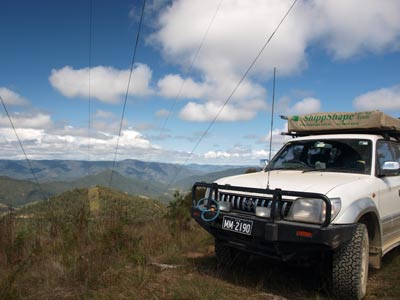
At GPS xxx we turn right onto a track that leads to a high tension power tower. It is very steep, with low range needed on at least one section. I used second and third low range. At the top there is a great view over the Georges Creek valley. We get here at 11:15 am and stop for morning tea.
At 11:45 am we leave the powerline. We continue along the access track. At one spot it is only metres from the main road, but about 20 metres above it. At noon we stop at an abandoned and derelict forestry hut. There are also some rotten picnic tables here. Not worth the effort of stopping.
 | 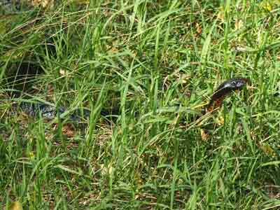 |
| The view from the power tower to Georges Creek Valley | A red bellied black snake in the
camping area at Halls Peak |
Soon after we turn left onto Raspberry Road. This is 22 kilometres from Georges Junction. There is a large sign here indicating the road leads to Halls Peak Camping Area and both East and West Kunderang.
Raspberry Road turns out to be an excellent forest road, in far better condition than the main Kempsey-Armidale Road. How hopeless is the Roads and Traffic Authority of NSW that it cannot even maintain the main road between Armidale and the coast to a standard of a forest road?
It is 25 kilometres along this road to the turn-off to Halls Peak. This track is sign-posted 4WD only but this first section is very deceiving as it is easy. One kilometre along you come to a locked gate. For reasons unknown, the access to the camping area is restricted and you need to pay a fee and get a key.
We enter and just after call on UHF 10 as directed. There is someone coming up. They advise they will reverse back to a section where we can pass. At a sharp hairpin turn we find a Land Rover 110 Series reversing with its camper-trailer. The sign up above says trailers are only permitted with special permission. Not exactly sure why, as although steep, the track is in good condition.
Anyway, we pass the Land Rover and continue down. It is steep all the way and very steep in a couple of spots. For one section, I use low range first gear to save the brakes. It is low range the whole way.
Halls Peak Camping Area is located on the Chandler River. This river comes from the Wollomombi Falls area where the Wollomombi River and Chandler River join. At the bottom there is a day use area. I would not think many people would bother going to the trouble to pay and get a key for a few hours visit. Off to the right is what is sign-posted as group camping. However, when we later look at this we find that it would be a very poor place to have to camp as the grass is over our knees and there is a portable horse corral taking up a good section of the area. This is used for storing wild horses that are being removed from the park (there are many as you will see).
We drop down to the lower area and see that there is camping to the left and the right. We head left and find some very nice spots. However, they are quite a way from the water's edge as the river is on the other side of the bed (remember that most Australia rivers are normally very dry and hardly ever cover the whole of their river bed).
Further along there is a sign that says you cannot go past this point. There is a very defined track that continues on and crosses the river. I understand that these signs are very new and that it was very common to cross the river and camp a lot further down on the National Park or private property.
We have a look around before deciding to have lunch by the river at 1:25 pm. We are back on the way at 2:15 pm, deciding to back track to the other part of the camping area to look for a spot. All the sites have excellent barbecues, with space for a camp oven, a swing BBQ plate and a paved flat area. There is also a toilet at each area.
We go back to the access track from the day use area and continue to the west. Here you drive on the dry rocky river bed before climbing back up a small bank to an area under the trees. These spots are not as nice as the other ones, but the river is much closer. In the end, after a lot of discussion, we decide to camp back on the rocky river bed.
 |  |
| Our set up at Halls Peak Camping Area | Some of the brumbies at Halls Peak Camping Area |
Just as we decided to set up camp, some wild horses (brumbies) come down and the girls and the kids take off after them. They alter report that one appears to have broken its foreleg and cannot walk very well at all. Finally, at about 3:00 pm we set up camp. We get a fire going as Kelly and I are making pizzas and Eric and Jane are doing roast chicken and vegies.
Once set up, most of us go for a swim. The water is quite warm for a river, about 18ºC or 19ºC I reckon. It is very nice once you get in. Saves having to have a shower, although a couple of the girls decide they want a warm shower so I still have to set it up.
I make the dough for our pizza bases and then we read for the rest of the afternoon.
 |  |
| Eric playing the guitar while we sit around the fire | After dinner fire at Halls Peak Camping Area |
About 5:00 pm decide to start cutting up the stuff for the toppings. We have two types of salami, chicken, chorizo sausage, cabanossi, capsicum, onion, tomato and pineapple. I then make the bases. This is done by splitting the dough into four pieces (probably could do five I reckon) and rolling them out with a beer can (perfect size).
Our pizzas need to fit in the base of the camp oven (in fact in a cake tin) so they end up just under 200 mm across. The bases are placed on aluminium foil for easy placing and removal from the camp oven. We are making two garlic and herb pizzas to share with the others so we only have two real pizzas to make. Kelly makes the garlic ones while I do the others.
On the bases we put some pizza base which comes in a small sachet. This easily covers the two bases (it will do three). We then put some mozzarella cheese and then tomato. On one, I put the two salamis, chorizo, cabanossi together with onion and capsicum. The other just has chicken, chorizo and pineapple. Some mixed herbs go on this and then more cheese. Ready for the camp oven.
The camp oven is heated to a very high heat by placing it on the fire and getting direct flames. You need it to be very hot to cook properly and I have found that it is hard to do this with coals alone. We cook the garlic ones first, they take about four to five minutes. They are excellent. In between, we reheat the oven.
The first pizza goes on and takes about six minutes to cook. It is done perfectly, with the base exactly as it should be. The second one takes about five minutes as the oven is kept hotter between the cooking.
These pizzas are better than any pizza I have eaten in any restaurant. They are easy to do and can use left over meats from pre-dinner drinks (eg the salami and cabanossi). I have cooked these about 400 kilometres from the nearest pizza place when out in the Central Australian desert. One of my favourite camping meals (Kelly and I have our own home-made wood fired pizza oven in our backyard - I will have write it up on the web site).
It was a lot cooler today and there are no many stars out as it got cloudy. We have a few drinks before heading to bed at about 10:00 pm. As is normal on camping trips, I sleep very well. It is again warmer tonight, probably due to the cloud cover.
Kilometres: 69 kilometres
Weather: Fine, maximum of 18-19ºC
For the next part of this trip, click here.
|  v6.00.307 © 2003-2005

