|
Michael McFadyen's Scuba Diving - Lanercost
The Lanercost was launched in October 1865 at Harrington, UK. She was a timber barque, 123.7 feet long and almost 26 feet wide and displaced 358 tons. She was originally constructed for the Holland to England trade. The early life of the ship is not known but the final owner was Mr Simpson of Adelaide.
On 21 November 1872 the Lanercost, under the command of Captain Simpson (not sure if this was the owner) departed Newcastle (New South Wales) to Adelaide with 580 tons of coal. At 5 am on 24 November 1872, the ship strayed a bit too far to the west and ran aground on a small point just north-west of Mowarry Point, south of Eden. The Sydney Morning Herald reported that the wreck was half a mile south of Mowarry Point but it is more likely that this was an incorrect report as there is no wreck at that location except the much more recent wreck of the Olive Cam. The crew all managed to get shore.
Men from the Eden pilot boat attempted to board her in a salvage attempt but big seas prevented the crew from succeeding. The seas were breaking over the ship's lower years and soon smashed the Lanercost to bits.
In the 1960s divers found the wreck and there was some minor salvage undertaken, including sand dredging of a major section on the sand. Sydney wreck diver John Riley found an American one cent coin on the wreck in the 1970s. This is dated 1864 and confirms the wreck as being the Lanercost rather than the Olivier Frost which sank south of here in 1856. Eden diver John Mathieson recovered some items over the years, including a key, a silver-plated spoon, a ship's log vane, the lens of a telescope and a copper spike.
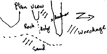 |
A plan of the wreck location showing
wreckage location and rock platforms |
The actual wreck site is quite easy to find. The GPS Reading for the site is approximately 37° 08.1896' S 149° 59.5562' E (using WGS84 as the map datum). If you use another datum you may be about 220 metres off the wreck. See my GPS Page for more details and how to convert readings. This will put you off a small point that juts a bit to the north from the shore. The wreck is scattered in the long gully to the east of the point and there is a major piece of hull on the sand in front of the second gully. You will need westerly or southerly winds to dive this wreck as you must have absolutely millpond seas.
After anchoring in this area, drop to the reef and swim to the south-east till you hit the sand. This is in the second gully. Follow this gully to the north-east and when you are in 20 to 21 metres, go out on the sand about five or ten metres and have a look around. If you are lucky, the sand overlaying the largest part of the wreck may have receded a bit exposing some hull timbers and the keel.
From here, swim back up the gully a bit before crossing over the ridge to the west and dropping into the main gully. Follow this gully up to the shallows, keeping primarily to the left side but zigging out a bit as you go. When you reach five metres, cross to the other side and work your way down deeper. Again, zag away from the wall and look for pieces of wreck. Along this side you will see an anchor a little bit up the wall on a small ledge. The bits of wreckage are mainly small pieces of iron, some copper (nails mostly) and some timber remnants.
Like most of the other Eden/Green Cape wrecks, people not interested in shipwrecks may find it a bit boring. In my view, it is worth a dive or two.
References:
|  v6.00.307 © 2003-2005

