|
Back in the 1980s I spent a lot of time fighting bushfires in the Wolgan Valley in the Blue Mountains. Newnes is located to the north of Lithgow on the western side of the Blue Mountains. The valley is like a large canyon which is surrounded by shear walls on all sides, giving a dramatic terrain from within and above. When fighting the fires, I once spent about four days and nights camped on a mountain top running a radio relay in which my work partner and I retransmitted radio messages from crews inside the valley to the headquarters at Blackheath. It was an interesting time, boiling hot during the day and freezing cold at night. I also spent time fighting the fire on the old railway line.
Since then I have been to the valley a number of times on four wheel drive camping trips. The following will describe a variation of a trip I have done a number of times. The trip as described is suitable for soft-roaders (SUVs) as the road is not too bad. A lot of it is even suitable for normal cars and I will point out the bits that are not. The following is a trip starting Saturday morning and finishing Sunday afternoon that we did in November 2012. On the trip we have:
From Sydney, we head out towards Richmond. Most groups who head off towards this area and need a meeting place meet at the McDonalds in Richmond (March and East Market Streets). From the east and south, you should take the M5 or M4 to the west and then the M7 north. Exit at the Richmond Road exit. It will take about 60 minutes from the Sutherland Shire and perhaps 70 minutes from the Eastern Suburbs.
Our plan is to meet here at 8:15 am and most arrive about that time. We planned to leave at 9 am at the latest, but one unnamed car load is very late. After breakfast and some waiting, we head off towards Kurrajong Heights and up the Bells Line of Road even though they have not yet arrived. They will follow and catch up to us. This is a slow climb as the road is mostly single lane and very windy. The maximum speed limit is only 80 kilometres per hour, but this is enough. It takes about two hours to get from Richmond to the old Zig Zag Railway. This is located just past Bell. The sign to the Zig Zag is blacked out and cannot be read, so note that it is about one kilometre past the Clarence Colliery.
The Zig Zag Railway is now closed, seemingly for good, as it was unable to meet the requirements of the railway safety authority. This is a great pity as it was a fantastic historic feature. The Zig Zag Railway was how the trains originally descended from the top of the Blue Mountains to the western slopes at Lithgow and was considered in its day to be an engineering marvel of the world. It was built in the 1860s but was only used for a short time before alternative tunnels were built which descended in a more direct and quicker route.
We still stop here and have a look at the Clarence Railway station and some of the rolling stock. We end up staying here quite a while waiting for the last car to arrive. We are now about an hour behind schedule. If they were not a relative, I certainly would have left without them!
From here we take the road that comes off the highway (Newnes Forest Road) and then cross over the railway line. This is a reasonably good dirt road. The road then becomes the Old Bells Line of Road. This soon enters Newnes State Forest and winds around a bit and then comes to a T intersection with Glow Worm Tunnel Road. We turn right here.
 |  |
The route of the railway from the main railway
at Clarence to north of Bungleboori
Click to enlarge | The route of the railway from north of Bungleboori
to just before the first tunnel
Click to enlarge |
About 2.5 kilometres along there is another intersection. This is with Beecroft Track (which some call Blackfellows Hand Track but that starts a bit further down Beecroft). At the intersection there used to be a nice camping area called Bungleboori Camping Area. However, this is now in a disgusting state and NSW State Forests has closed it and appears to have simply wiped its hands of regulating the use. It looks like many idiots use this (probably because it is very close to Lithgow) for a drinking spot. There are broken bottles and rubbish everywhere. Look elsewhere for a camping spot, despite what you read on other web sites.
We stop here for morning tea. Normally we would have had it further further along the road. We continue along the Glow Worm Tunnel Road. This section is not as good as the bit we have been on already, it has some very corrugated sections and is also narrow in spots. This road can be very slippery in the wet, in fact I once came across a small SUV tipped on its side here (luckily the occupants were not hurt).
 |  |
The route of the railway from south
of the first tunnel to Newnes
Click to enlarge | A map of the end of the railway at Newnes |
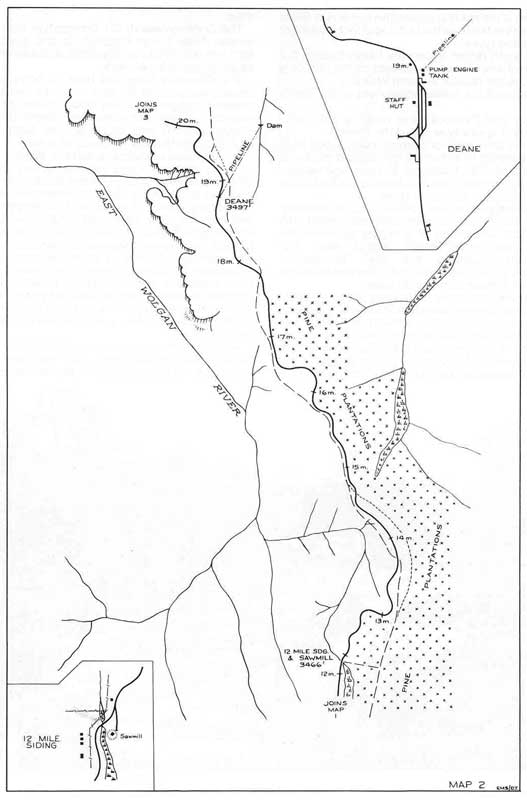
There are a number of tracks that come off this road. The ones to the left head out towards the Wolgan Valley cliff face. There are some spots to camp at the end of these roads, but there is not much room. Fire Trail No 4 has a small spot at the end for a couple of cars. Soon after we leave Bungleboori we enter into a pine forest. Around this spot the road actually starts to follow the old railway line that ran from the main western line (back near Clarence) to Newnes. This railway was used to carry equipment and men into the valley and take out the product (more about this later). I should add that part of the road you were on before Bungleboori was also the railway line.
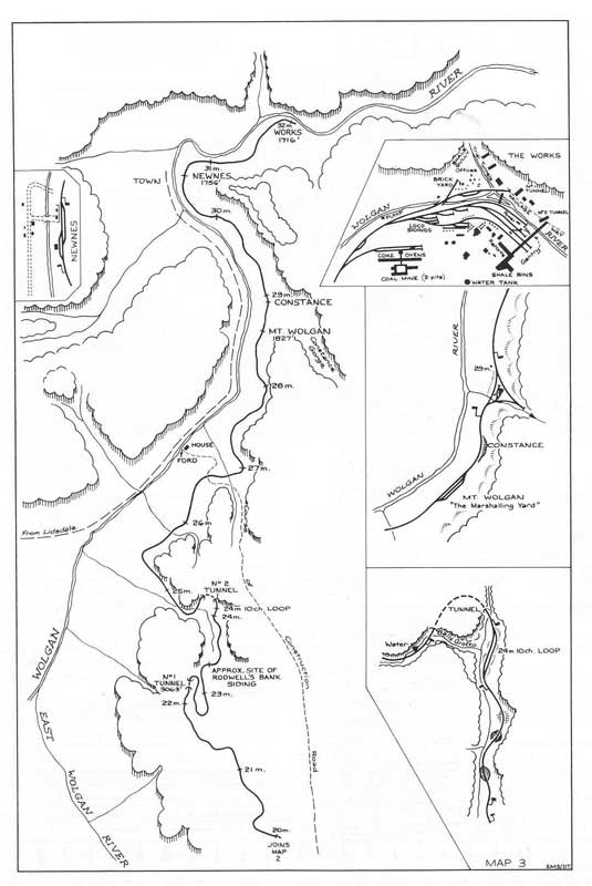
The Wolgan Valley Railway was built to service the Newnes Shale Oil Refinery. The railway was surveyed starting in April 1906 and in November 1906 construction began. It was completed a year later just after November 1907! This was an incredible construction feat as you will see from photos on this site as well as when you visit.
The train line was a standard gauge meaning that carriages could transfer from this line to the main NSW railway lines. The actual route of the line has never been clear to me till 2012 when I found a map of the route. However, the section that you drive on is fairly obvious as the road has a very slight descent and very smooth curves. The total length of the line was 51 kilometres. The line was closed in 1937 when the refinery closed down.
 |  |
| A map of the Glow Worm Tunnel | I think this train is entering the south side
of what is now the Glow Worm Tunnel |
I have added to this page three scans from an old book I found which show the full route of the railway line. I have also added some blow-ups from certain parts of the map.
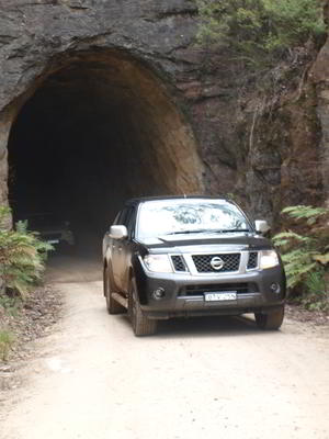
As we get closer to the end of the road, we will see some interesting rock formations. These are called "pagodas". There are more of these to see later in the trip, so we do not stop here. About 24 kilometres from Bungleboori the road enters a cutting and then the shorter of the two tunnels. This was officially called No 1 Tunnel. This tunnel is 110 metres long and curves to the right. It is very high and quite wide, unlike some other old mining tunnels we have driven through.
From here the road does a large back to front S and drops relatively dramatically for a railway line. Around a few corners and it ends up at a parking area. This has a toilet (very, very smelly whenever we have visited). We park here and walk approximately one kilometre to the Glow Worm Tunnel. This is what was called No 2 Tunnel. It is longer of the two tunnels on the railway line.
 | 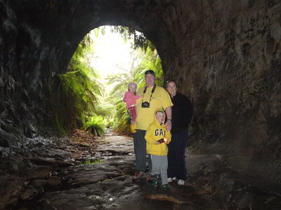 |
| The exit of No 1 Tunnel on the northern side | Karl and Janelle Hartmann with Isabelle and Joshua
|
It is a very nice walk to the tunnel, following the old railway line. At one spot the bridge across a creek is missing and there is a small walking bridge to cross over the creek. From reading the book on the railway line, it seems that near here the engines needed to rewater and passengers sometimes got out and walked this section and then reboarded the train a bit further on. The line follows more cuttings and crosses small valleys on an earth embankment. Near the tunnel a creek runs alongside the track, but partly underground. See the enlarged section of the map.
The Glow Worm Tunnel is at the end of another cutting. This tunnel has the creek running through the bottom and is very wet and care needs to be taken. We also need a torch as it is pitch black inside. The tunnel is 404 metres long and curves to the left, quite sharply in fact. Within 50 metres or so it is very dark. We turn off our torch and straight away we see glow worms. These are not actually worms, but the larvae form of a gnat. They emit a soft bluish glow. The walls and roof of the tunnel look like the night sky, with lots of stars out. Brilliant!
Once we have spent enough time inside we head back to the car. The walk takes about one hour at the most. It will now probably be time for morning tea. Once finished, drive back to Bungleboori. On the way back we spotted a whole lot of waratahs in the bush on the side of the road. These are not very commonly seen, so we stop and take some photographs. They are such a beautiful flower.
Back at the intersection, you can visit The Lost City. This is a large area of pagodas. The track to The Lost City comes off Beecroft Road which is the road opposite the camping area. It is only 30 or 40 metres from the Glow Worm Tunnel Road to this track. Turn left into this track and a few hundred metres along you will go across a cleared area under powerlines. Cross this and then take the left branch of each of the three Y intersections you come to. However, we do not have time as we are running too late.
 |  |
| One of a bunch of waratahs we found, beautiful | Gary and Nancy on top of one of the pagodas
|
It is about three kilometres from Beecroft Road to The Lost City car park. You used to be able to drive all the way to the pagodas, but now you need to walk a short distance. You should allow about 30 minutes for this. After you finish the walk it is probably time for lunch.
From here we backtrack to Beecroft Road and turn left. We are now heading west. The road eventually becomes Blackfellows Hand Track. This turns north and then west again. We collect firewood along these roads as there is plenty available. Make sure you do it early before you enter the national park (probably better to do on the way to or from The Lost City). Most of the road up here is at 1,100 metres or so.
Eventually the road starts to descend and eventually you come to a gully where the road goes through a series of pagodas (there are also some before this worth looking at). Turn right and park. This is a nice spot and there is a nice short walk here. You can also see some Aboriginal paintings on one of the overhanging rocks. These are on the right as you walk up the gully.
This is not Blackfellows Hand Cave, but some four wheel drive sites and guides call it that. The real cave is a bit further down the track. After a short look around, we get back in our vehicles and go back to the intersection only a few metres away.
 |  |
| The valley in between the pagodas, not the location of Blackfellows Cave | One of the Aboriginal paintings in the pagodas
|
We head down the track and after about 200 metres I spot the cleared area on the left where Blackfellows Hand Cave is located. As we are running late, we do not stop here but if you have left on time, then you should easily be able to visit and still arrive in Newnes with plenty of time to spare.
This is a tar road that heads back towards the Castlereagh Highway and Lithgow. Straight across the road is another dirt track. This leads to the Gardens of Stone National Park and a track that ends up near Capertee.
We turn right and within 500 metres we start a very steep descent into the Wolgan Valley. Just before you start the descent, if the weather is fine, pull off to the right side of the road into a large parking area which gives a brilliant view into the valley. It is normally spectacular, but today it is misty and there is no view. The road down is now tar to the bottom, but there are some narrow parts and tight turns and you need to take it slowly.
Once on the bottom of the valley (we have dropped xxx metres from the top), the dirt road winds along the valley. It is not too bad a road, but when wet, it is very, very slippery. It is xx kilometres to Newnes. About seven kilometres before Newnes you will probably see some cars parked on the right. This is the start of the walk to the Glow Worm Tunnel from the bottom. It takes about four hours to do the return trip. The weather has improved a lot in the valley and it is now sunny. There has obviously been very little rain here, unlike the plateau which had lots of water puddles on the road.
 | 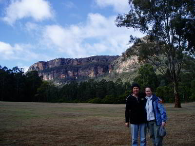 |
| The view into Newnes Valley | Kelly and Michael in 2006 on a trip here
|
When we arrive at Newnes pass the old pub on the left. Back in January 1983 I had a beer in the Newnes Hotel. At that time it was located on the opposite side of the road (you can still see the foundations). The hotel is now not licensed. There is a camping area here (and some cabins?) which you need to pay the hotel to use. When we visited in 2012 there was a wedding reception underway here.
We continue past the hotel. On the right there is a track which leads across the Wolgan River. This is not deep, but a soft-roader will probably not be able to cross as it is a very soft sand bottom. There are numerous camping areas on that side of the river, ranging from quite large to small for one or two vehicles. We keep going past the crossing where there is another cleared area. We are now in Wollemi National Park. This is stated to be a picnic area, but people regularly camp here, including today.
Further on we come to another water crossing. This goes over the Capertee Creek and leads to the main camping area. The crossing is via a concrete causeway and normally is very easy. However, I once had to cross it when it was in flood and the water came up to the bonnet (see photo). This camping area is huge, capable of handling a hundred people or more. There are probably 20 vehicles here all up.
 |  |
Robbie Mapstone crossing the Capertee Creek
when it was in flood, about 2002 |
|
There are two toilets here, but no other facilities. We spread out and have a look around before selecting a spot that will fit all of us and not be too close to the other people here. Kelly and I are set up within a couple of minutes so we then set about helping those using borrowed tents. Everything goes well and soon we are all set up.
If there are too many people camped here you can go back and cross the Wolgan River (if you have a 4WD) and check out the other spots.
It is now about 4:30 pm, so Ron and I start the campfire. A few people go for a short walk and the kids start playing. By 5 pm we have a good fire going, but as we need a lot of coals to cook our dinners, we pile on the timber.
This site has lots of wildlife, kangaroos and wallabies, wombats and plenty of birds including waterfowl (not sure what they were - not ducks, but mother and father and 10 "ducklings"). The waterfowl and the roos wander around the camping area, coming quite close to us at times. In summer watch out for funnel web spiders, we have seen them here on the grass.
 |
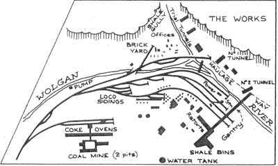
| A photograph showing part of the Newnes Shale Oil Refinery |
Drinks o'clock comes (5 pm) so we open a few beers, wines and champagne and have some cheese, biscuits and chips. Very civilised! As we have a lot of first time campers with us, Ron and I have planned to cook up two sets of shared meals of beef, pork and lamb with lots of roast vegetables. The meat is not a traditional roast, but marinated "butterfly" cuts of meat. They are cooked on the barbecue and generally take much less cooking. It is a bit of a challenge to time the finishing times as each cut has a different cooking time. The pork goes on first, then the lamb and only 10 minutes before the end, the beef. Meanwhile Kelly has prepared our vegies and put them on first.
Donna has made some pork dumplings and she cooks them in a camp oven. We have these as entrees. Yum. Finally, after 60 minutes from putting on the first meat, they are all ready. We carve up the meat and distribute the vegies. What a great meal in a great location!
After dinner we have a joint effort at washing up (heating the water using our car shower) and then sit around the fire having a few more drinks and some chocolate courtesy of Eda. The kids have already gone to bed, we have fed them separately, so it is quite nice. Even the running of a generator at the closest camp site does not disturb us, it is very quiet. We are all in bed by 11 pm.
This camping area can get busy on summer weekends, but during the week and in winter it is all but deserted. Even with the numbers here tonight it was not crowded.
The next day we have a very relaxing start to the morning. We do not get up till after 8 am, even the kids are not up till then. Apparently it rained during the night but I never heard a thing. Karl says it was only for a minute or two.
We get the fire going again and then cook up some bacon and eggs. A great start to the morning.
We pull up camp and by 10:30 am we are ready to leave. We head back across the creek and stop at the river crossing. I decide that I do not want to attempt it with the soft-roaders, so we park them here and load some gear out of the 4WDs into them so that everyone will fit for the short drive to the shale oil refinery ruins. We cross the river and a kilometre or so along come to the parking area.
We do the walk, signposted as two hours. We end up spending probably 90 minutes exploring, but some of us have been here before. It is a fascinating place to see, such a large industrial site built in what was then and even now) is a relatively remote area. The kids have a great time examining the ruins.
We leave at 12 noon and my sister Janelle decides to head straight home. The rest of us decide that we will visit Blackfellow Hands Cave on the way out and perhaps visit Hartley Historic Site. As we exit the valley I stop to take a photo looking back into the valley as it is now clear, unlike yesterday. A few hundred metres along we turn leave back into Blackfellows Track and about 500 metres along I turn right into the cleared area I spoke of earlier.
We drive to the start of a very steep and rough track. This runs up the hill about 100 metres to a large rock outcrop. I have driven up this hill once before, but unless you are experienced, do not attempt it. Note that only one car can do this at once as there is only space for one car to turn around at the top.
We walk up the hill to see the paintings. At the top you will see a very large rock overhang. It is like a huge wave about to break. Look along the lower parts of this "wave" and you will see dozens of hand stencils. They are all over the place. There are also stencils of a boomerang, some complete forearms and what appears to be a stone axe. This is Blackfellows Hand Cave.
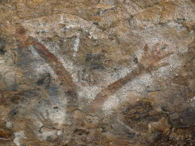 | 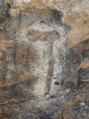 |
| Some red hands at the Blackfellows Cave Aboriginal Site | A painting of an axe
|
We spent about 15 minutes looking at the paintings and then headed back to the cars. It is now lunch time so we have something to eat. After this we go back onto the track and turn left. At Wolgan Road we turn left and head towards Lithgow. We have decided to head straight home. We get a good run over the mountains and I am home by just after 4 pm.
This has been a great weekend, the first time for ages that Kelly and I have been camping on a weekend (most have been for extra-long weekends and weeks away). This is a very good trip, especially for beginners and those without a 4WD. You could even do most of the trip in a normal passenger car. The only section you could not do would be the section from Bungleboori to Blackfellows Hands Cave. You would need to head back into Lithgow from the Glow Worm Tunnel and then take the tar road to the start of the Wolgan Valley.
References:
|  v6.00.307 © 2003-2005

